
|
January 6, 2014 |
|
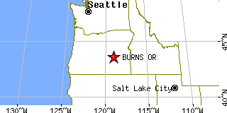
Burns, ORHarney County, Oregon
Latitude: 43.586827 Longitude: -119.057114Population 2,755 (2005)Elevation of Burns, Oregon: 4100 feet |
|
Population 2005: 2,755 Population 2004: 2,836 Population 2003: 2,889 Population 2002: 2,937 Population 2001: 2,979 Population 2000: 3,064 (2000 Census) Population 1990: 2,913 (1990 Census) Population Growth 2000 to 2005: -10.08% Population Growth 1990 to 2000: 5.18% Population (2000 Census): 3,064 Male: 1,535 (50.10%) Female: 1,529 (49.90%) Median age: 38.70 years Races, 2000 Census: White: 89.98% Hispanic or Latino: 5.29% American Indian: 2.48% Two or more races: 2.06% Other race: 1.11% Asian: 0.52% Black or African American: 0.20% Native Hawaiian / Other Pacific Islander: 0.10% Housing Units: 1,487 (2000 Census) Land Area: 3.5567 square miles Most populous zip code: 97720 |
 |