
|
January 6, 2014 |
|
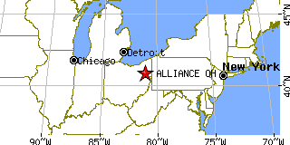
Alliance, OHStark County, Ohio
Latitude: 40.913358 Longitude: -81.108094Population 22,801 (2005)Elevation of Alliance, Ohio: 1174 feet |
|
Population 2005: 22,801 Population 2004: 22,858 Population 2003: 22,990 Population 2002: 23,110 Population 2001: 23,143 Population 2000: 23,253 (2000 Census) Population 1990: 23,376 (1990 Census) Population Growth 2000 to 2005: -1.94% Population Growth 1990 to 2000: -0.53% Population (2000 Census): 23,253 Male: 10,851 (46.66%) Female: 12,402 (53.34%) Median age: 34.00 years Races, 2000 Census: White: 84.85% Black or African American: 11.19% Two or more races: 1.93% Hispanic or Latino: 1.17% Asian: 0.77% Other race: 0.41% American Indian: 0.17% Native Hawaiian / Other Pacific Islander: 0.02% Housing Units: 9,730 (2000 Census) Land Area: 8.6118 square miles Water Area: 0.0024 square miles Most populous zip code: 44601 |
 |