
|
January 6, 2014 |
|
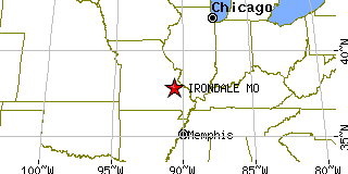
Irondale, MOWashington County, Missouri
Latitude: 37.835204 Longitude: -90.672505Population 445 (2005) |
|
Population 2005: 445 Population 2004: 441 Population 2003: 443 Population 2002: 440 Population 2001: 439 Population 2000: 437 (2000 Census) Population 1990: 474 (1990 Census) Population Growth 2000 to 2005: 1.83% Population Growth 1990 to 2000: -7.81% Population (2000 Census): 437 Male: 216 (49.43%) Female: 221 (50.57%) Median age: 34.10 years Races, 2000 Census: White: 96.80% Two or more races: 1.60% Hispanic or Latino: 0.92% Asian: 0.46% American Indian: 0.23% Housing Units: 198 (2000 Census) Land Area: 0.5437 square miles Water Area: 0.0164 square miles Most populous zip code: 63648 |
 |