
|
January 6, 2014 |
|
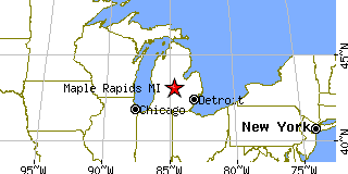
Maple Rapids, MIClinton County, Michigan
Latitude: 43.103314 Longitude: -84.692774Population 614 (2005) |
|
Population 2005: 614 Population 2004: 619 Population 2003: 624 Population 2002: 629 Population 2001: 641 Population 2000: 643 (2000 Census) Population 1990: 680 (1990 Census) Population Growth 2000 to 2005: -4.51% Population Growth 1990 to 2000: -5.44% Population (2000 Census): 643 Male: 319 (49.61%) Female: 324 (50.39%) Median age: 34.20 years Races, 2000 Census: White: 98.76% Hispanic or Latino: 0.47% Other race: 0.31% Two or more races: 0.16% Housing Units: 262 (2000 Census) Land Area: 1.4102 square miles Most populous zip code: 48853 |
 |