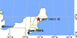
WEST PARIS is located in OXFORD county, Maine at latitude 44.325285 and longitude -70.524515. The population of WEST PARIS is 1,745 as of the year 2000. The most common zip code of WEST PARIS is
04289.
|
|
Population 2000: 1,745 (2000 Zip Code Based Est.)
Housing Units: 731 (2000 Zip Code Based Est.)
Land Area: 24.6779 square miles
Water Area: 0.1571 square miles
Most populous zip code: 04289
|
 |

|
Cities & Towns nearby West Paris
Sumner, ME 6mi NE
Bryant Pond, ME 6.8mi NW
South Paris, ME 7.2mi S
Greenwood, ME 7.7mi WNW
Norway, ME 7.9mi S
Buckfield, ME 8.1mi ESE
Hebron, ME 11.7mi SE
Canton, ME 12.4mi ENE
Peru, ME 12.5mi NNE
Waterford, ME 13mi SW
US Beacon Home


