
|
January 6, 2014 |
|
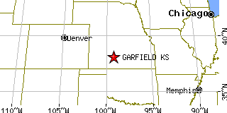
Garfield, KSPawnee County, Kansas
Latitude: 38.076310 Longitude: -99.244994Population 186 (2005)Elevation of Garfield, Kansas: 2075 feet |
|
Population 2005: 186 Population 2004: 186 Population 2003: 187 Population 2002: 189 Population 2001: 193 Population 2000: 198 (2000 Census) Population 1990: 236 (1990 Census) Population Growth 2000 to 2005: -6.06% Population Growth 1990 to 2000: -16.10% Population (2000 Census): 198 Male: 98 (49.49%) Female: 100 (50.51%) Median age: 42.00 years Races, 2000 Census: White: 97.98% Other race: 0.51% Housing Units: 97 (2000 Census) Land Area: 0.5361 square miles Most populous zip code: 67529 |
 |