
|
January 6, 2014 |
|
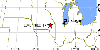
Lone Tree, IAJohnson County, Iowa
Latitude: 41.485871 Longitude: -91.426692Population 1,081 (2005)Elevation of Lone Tree, Iowa: 720 feet |
|
Population 2005: 1,081 Population 2004: 1,160 Population 2003: 1,160 Population 2002: 1,154 Population 2001: 1,146 Population 2000: 1,151 (2000 Census) Population 1990: 979 (1990 Census) Population Growth 2000 to 2005: -6.08% Population Growth 1990 to 2000: 17.57% Population (2000 Census): 1,151 Male: 567 (49.26%) Female: 584 (50.74%) Median age: 35.10 years Races, 2000 Census: White: 98.70% Two or more races: 0.52% Other race: 0.26% Black or African American: 0.17% Asian: 0.09% Housing Units: 489 (2000 Census) Land Area: 0.9878 square miles Most populous zip code: 52755 |
 |