
|
January 6, 2014 |
|
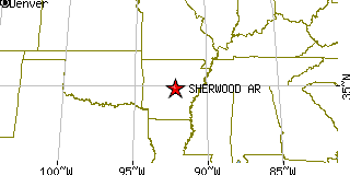
Sherwood, ARPulaski County, Arkansas
Latitude: 34.830890 Longitude: -92.211514Population 23,149 (2005)Elevation of Sherwood, Arkansas: 330 feet |
|
Population 2005: 23,149 Population 2004: 22,528 Population 2003: 22,217 Population 2002: 21,934 Population 2001: 21,712 Population 2000: 21,511 (2000 Census) Population 1990: 18,893 (1990 Census) Population Growth 2000 to 2005: 7.61% Population Growth 1990 to 2000: 13.86% Population (2000 Census): 21,511 Male: 10,449 (48.58%) Female: 11,062 (51.42%) Median age: 35.90 years Races, 2000 Census: White: 85.34% Black or African American: 10.14% Hispanic or Latino: 2.05% Two or more races: 1.24% Asian: 0.95% Other race: 0.83% American Indian: 0.43% Native Hawaiian / Other Pacific Islander: 0.06% Housing Units: 9,272 (2000 Census) Land Area: 13.8077 square miles Water Area: 0.2229 square miles Most populous zip code: 72120 |
 |